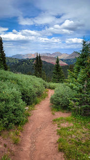
I went to the woods...

Chris aka "Aerofly"
On July 30th, I set out on one of the biggest adventures of my life as I thru-hiked the 491 mi Colorado Trail “NoBo” from Durango to Denver via Collegiate West.
As a kid, backpacking trips up to the Big Horns with my family gave me a deep respect for the ruggedness of the American West, but nothing like the technical mountaineering I encountered in the San Juans and the ~90,000 ft of total elevation gain on trail.
I was excited for (and afraid of) this wild journey of exploration as I set out to reconnect with nature in the most raw and primitive sense while testing my own personal will and strength to finish this crazy adventure.
As I’ve found in other areas of my life, embracing my deepest fears and “hugging the monster” is scary as hell but has always led me towards the most meaningful growth as a person.

"I went to the woods because I wished to live deliberately, to front only the essential facts of life, and see if I could learn what it had to teach, and not, when I came to die, discover that I had not lived." - HDT
Follow my Journey
Follow me on trail as I journey towards Waterton Canyon:
Garmin Explore ➜ inReach location every ~15 min HERE.
HERE to view full-screen view.

** Very approximate. Doesn't account for "zero" days needed to address any injuries.**
Gear
HERE is the gear I carried on trail. I shipped some items in resupply boxes to optimize overall weight.
Longest Food Carry: 7 days from Molas Lake to Monarch Pass (153 mi)
# of Resupplies: 3 stops over ~20 days
About the CO Trail
The Colorado Trail is one of the highest and remote long-distance hiking trails in the US stretching 491 miles from Durango to Waterton Canyon just south of Denver.
The trail traverses some of the highest points of the hydrologic divide as it winds through 8 mountain ranges, 6 national forests, 6 wilderness areas and 5 major river systems.
The dramatic rises & falls of the trail give it ~89,000 ft of total elevation gain ranging from 5,500 ft at the Waterton Terminus all the way up to 13,271 ft on the slopes of Coney in the San Juans.
The trail runs concurrent with the Continental Divide Trail (CDT) for 240 miles as it follows the continental divide through Colorado.


© 2025 CHRIS SANDERS | Denver, CO | csanders1@babson.edu |


